
Treorchy topographic map
Interactive map
Click on the map to display elevation.
About this map
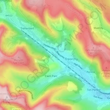
Name: Treorchy topographic map, elevation, terrain.
Location: Treorchy, Rhondda Cynon Taf, Wales, Vereinigtes Königreich (51.63903 -3.56402 51.68646 -3.48680)
Average elevation: 1,033 ft
Minimum elevation: 482 ft
Maximum elevation: 1,706 ft
Other topographic maps
Click on a map to view its topography, its elevation and its terrain.
Cwm Parc
Vereinigtes Königreich > Wales > Rhondda Cynon Taf
Cwm Parc, Rhondda Cynon Taf, Wales, CF42 6LY, Vereinigtes Königreich
Average elevation: 1,014 ft
Aberdare
Vereinigtes Königreich > Wales > Rhondda Cynon Taf > Aberdare
Aberdare, Rhondda Cynon Taf, Wales, CF44 7NT, Vereinigtes Königreich
Average elevation: 902 ft