
La Murassaz topographic map
Interactive map
Click on the map to display elevation.
About this map
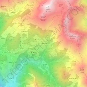
Name: La Murassaz topographic map, elevation, terrain.
Location: La Murassaz, Brusson, Vallée d'Aoste, 11025, Italie (45.74030 7.75920 45.78030 7.79920)
Average elevation: 6,650 ft
Minimum elevation: 3,953 ft
Maximum elevation: 9,049 ft
Other topographic maps
Click on a map to view its topography, its elevation and its terrain.
Castello di Graines
Italie > Vallée d'Aoste > Brusson > Brusson - Les Trois Villages > Le Ponteil
Castello di Graines, Strada Regionale 45 della Valle D'Ayas, Le Ponteil, Brusson - Les Trois Villages, Brusson, Vallée d'Aoste, 11022, Italie
Average elevation: 4,642 ft