
Chelghoum Laïd topographic map
Interactive map
Click on the map to display elevation.
About this map
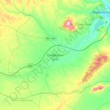
Name: Chelghoum Laïd topographic map, elevation, terrain.
Location: Chelghoum Laïd, Chelghoum Laid District, Mila, Algeria (36.08466 6.05227 36.24394 6.32193)
Average elevation: 2,736 ft
Minimum elevation: 2,264 ft
Maximum elevation: 3,868 ft
Other topographic maps
Click on a map to view its topography, its elevation and its terrain.
Oued Athmania
Algeria > Mila > Chelghoum Laid District > Oued Athmania
Oued Athmania, Chelghoum Laid District, Mila, Algeria
Average elevation: 2,730 ft