
Avesta kommun topographic map
Interactive map
Click on the map to display elevation.
About this map
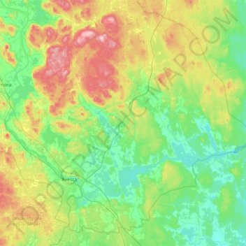
Name: Avesta kommun topographic map, elevation, terrain.
Location: Avesta kommun, Dalarna County, Sweden (60.06988 16.01699 60.37940 16.70460)
Average elevation: 387 ft
Minimum elevation: 184 ft
Maximum elevation: 892 ft
Other topographic maps
Click on a map to view its topography, its elevation and its terrain.
Hedemora kommun
Hedemora kommun, Dalarna County, Sweden
Average elevation: 531 ft
Ässån
Ässån, Smedjebackens kommun, Dalarna County, Sweden
Average elevation: 604 ft
Rättviks kommun
Rättviks kommun, Dalarna County, Sweden
Average elevation: 984 ft
Malung-Sälens kommun
Malung-Sälens kommun, Dalarna County, Sweden
Average elevation: 1,296 ft
Stöten
Stöten, Malung-Sälens kommun, Dalarna County, Sweden
Average elevation: 1,936 ft
Sälen
Sälen, Malung-Sälens kommun, Dalarna County, Sweden
Average elevation: 1,686 ft
Malung
Malung, Malung-Sälens kommun, Dalarna County, 782 31, Sweden
Average elevation: 1,119 ft
Idre
Idre, Älvdalens kommun, Dalarna County, Sweden
Average elevation: 1,588 ft