
Wisdom topographic map
Click on the map to display elevation.
Wisdom
Wisdom is located at 45°36′58″N 113°26′59″W / 45.61611°N 113.44972°W / 45.61611; -113.44972 (45.616120, -113.449742). According to the United States Census Bureau, the CDP has a total area of 0.99 square miles (2.56 km2), of which 0.98 square miles (2.54 km2) is land and 0.0077 square miles (0.02 km2), or 0.82%, is water. Wisdom's average elevation is 6,245 feet (1,903 m), about 1.2 miles above sea level.
About this map
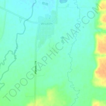
Name: Wisdom topographic map, elevation, terrain.
Location: Wisdom, Beaverhead County, Montana, 59761, United States (45.59843 -113.45377 45.62174 -113.43730)
Average elevation: 6,063 ft
Minimum elevation: 6,030 ft
Maximum elevation: 6,138 ft
Beaverhead County trails, hiking, mountain biking, running and outdoor activities