
Teterow topographic map
Interactive map
Click on the map to display elevation.
About this map
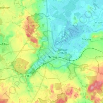
Name: Teterow topographic map, elevation, terrain.
Average elevation: 128 ft
Minimum elevation: -3 ft
Maximum elevation: 384 ft
Other topographic maps
Click on a map to view its topography, its elevation and its terrain.
Laage
Germany > Mecklenburg-Vorpommern > Landkreis Rostock
Laage, Landkreis Rostock, Mecklenburg-Vorpommern, 18299, Germany
Average elevation: 128 ft
Tarnow
Germany > Mecklenburg-Vorpommern > Landkreis Rostock
Tarnow, Bützow-Land, Landkreis Rostock, Mecklenburg-Vorpommern, Germany
Average elevation: 85 ft
Laage
Germany > Mecklenburg-Vorpommern > Landkreis Rostock > Laage > Laage
Laage, Landkreis Rostock, Mecklenburg-Vorpommern, 18299, Germany
Average elevation: 108 ft
Laage
Germany > Mecklenburg-Vorpommern > Landkreis Rostock > Laage
Laage, Landkreis Rostock, Mecklenburg-Vorpommern, 18299, Germany
Average elevation: 121 ft