Geolocate

Laage topographic map

Click on the map to display elevation.

Laage

To the west and east of the Recknitz-Urstromtal there are terminal moraines. Der Kalte Berg is 62m above the Normalhöhennull, the tallest point of elevation in the municipal area. Rostock Laage Airport is located a few kilometers west of Laage.

Wikipedia (CC-BY-SA 3.0)

About this map

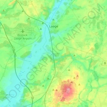
Name: Laage topographic map, elevation, terrain.

Location: Laage, Landkreis Rostock, Mecklenburg-Vorpommern, 18299, Germany (53.82026 12.21306 53.95527 12.46492)

Average elevation: 128 ft

Minimum elevation: 26 ft

Maximum elevation: 417 ft

Other topographic maps

Click on a map to view its topography, its elevation and its terrain.

Laage

Germany > Mecklenburg-Vorpommern > Landkreis Rostock > Laage > Laage

Average elevation: 108 ft

Gear up for your next adventure:

📱Solar Portable Charger - Solar power bank for charging devices off‑grid
🎒Waterproof Dry Bags - Keep your electronics and maps dry inside your pack
🪶Multi‑Purpose Knife - Useful blade for camp and trail
💧Water Filtration Bottles - Safely drink from streams and lakes while exploring
🥾Men's Hiking Boots - Durable, waterproof footwear for rugged terrain and steep inclines

As an Amazon Associate, this site earns from qualifying purchases at no extra cost to you.