
Δημοτική Ενότητα Μαντινείας topographic map
Interactive map
Click on the map to display elevation.
About this map
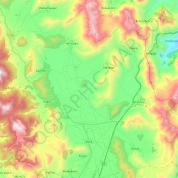
Name: Δημοτική Ενότητα Μαντινείας topographic map, elevation, terrain.
Average elevation: 2,946 ft
Minimum elevation: 961 ft
Maximum elevation: 6,089 ft
Other topographic maps
Click on a map to view its topography, its elevation and its terrain.
Tyros
Griechenland > Peloponnes, Westgriechenland und Ionische Inseln > Regionalbezirk Arkadien > Δημοτική Ενότητα Τυρού
Tyros, Δημοτική Ενότητα Τυρού, Δήμος Νότιας Κυνουρίας, Regionalbezirk Arkadien, Region Peloponnes, Peloponnes, Westgriechenland und Ionische Inseln, 220 29, Griechenland
Average elevation: 1,306 ft
Tripoli
Griechenland > Peloponnes, Westgriechenland und Ionische Inseln > Regionalbezirk Arkadien
Tripoli, Δημοτική Ενότητα Τρίπολης, Δήμος Τρίπολης, Regionalbezirk Arkadien, Region Peloponnes, Peloponnes, Westgriechenland und Ionische Inseln, 221 00, Griechenland
Average elevation: 2,864 ft