Geolocate

Thika topographic map

Click on the map to display elevation.

About this map

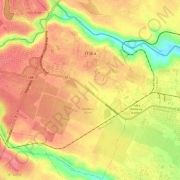
Name: Thika topographic map, elevation, terrain.

Location: Thika, Thika Town, Kiambu, Kenya (-1.06691 37.06370 -1.02721 37.11482)

Average elevation: 4,905 ft

Minimum elevation: 4,741 ft

Maximum elevation: 4,984 ft

Other topographic maps

Click on a map to view its topography, its elevation and its terrain.

Thika

Kenya > Kiambu > Thika Town

Average elevation: 4,905 ft

Maguguni

Kenya > Kiambu > Thika Town > Ngoliba ward

Average elevation: 4,564 ft

Athi

Kenya > Kiambu > Thika Town > Ngoliba ward

Average elevation: 4,593 ft

Gear up for your next adventure:

🪑Portable Camp Table - Compact table for campsite meals
🏕️Tent Footprint - Protect your tent base from wear
🥘Titanium Cookware - Durable, featherlight pots and pans for backpacking
👟Trail Running Shoes - Lightweight shoes for trail runners
🥤Water Filter Bottle - All‑in‑one filter bottle for safe hydration

As an Amazon Associate, this site earns from qualifying purchases at no extra cost to you.