
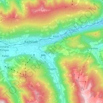
Radstadt topographic map
Interactive map
Click on the map to display elevation.
About this map
Name: Radstadt topographic map, elevation, terrain.
Average elevation: 3,888 ft
Minimum elevation: 2,641 ft
Maximum elevation: 6,414 ft
Other topographic maps
Click on a map to view its topography, its elevation and its terrain.
Filzmoos
Österreich > Salzburg > Bezirk St. Johann im Pongau
Filzmoos, Bezirk St. Johann im Pongau, Salzburg, 5532, Österreich
Average elevation: 4,616 ft
Bischofshofen
Österreich > Salzburg > Bezirk St. Johann im Pongau
Bischofshofen, Bezirk St. Johann im Pongau, Salzburg, 5500, Österreich
Average elevation: 3,307 ft
Karteis
Österreich > Salzburg > Bezirk St. Johann im Pongau > Hüttschlag
Karteis, Hüttschlag, Bezirk St. Johann im Pongau, Salzburg, 5612, Österreich
Average elevation: 4,652 ft
Sankt Martin am Tennengebirge
Österreich > Salzburg > Bezirk St. Johann im Pongau
Sankt Martin am Tennengebirge, Bezirk St. Johann im Pongau, Salzburg, 5522, Österreich
Average elevation: 4,117 ft
Schwarzach im Pongau
Österreich > Salzburg > Bezirk St. Johann im Pongau
Schwarzach im Pongau, Bezirk St. Johann im Pongau, Salzburg, 5620, Österreich
Average elevation: 2,402 ft
Großarltal
Österreich > Salzburg > Bezirk St. Johann im Pongau > Großarl
Großarltal, Hinterlaireiting, Großarl, Bezirk St. Johann im Pongau, Salzburg, 5611, Österreich
Average elevation: 3,770 ft
Zauchensee
Österreich > Salzburg > Bezirk St. Johann im Pongau > Altenmarkt im Pongau
Zauchensee, Altenmarkt im Pongau, Bezirk St. Johann im Pongau, Salzburg, 5541, Österreich
Average elevation: 5,272 ft
Remsach
Österreich > Salzburg > Bezirk St. Johann im Pongau > Bad Gastein > Remsach
Remsach, Bad Gastein, Bezirk St. Johann im Pongau, Salzburg, 5640, Österreich
Average elevation: 5,413 ft