Geolocate

Tulo topographic map

Click on the map to display elevation.

About this map

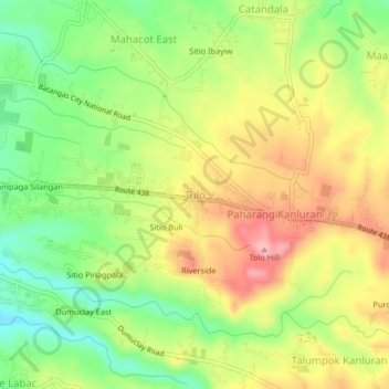
Name: Tulo topographic map, elevation, terrain.

Location: Tulo, Batangas City, Batangas, Calabarzon, 4200, Philippines (13.73384 121.11151 13.77384 121.15151)

Average elevation: 367 ft

Minimum elevation: 138 ft

Maximum elevation: 617 ft

Other topographic maps

Click on a map to view its topography, its elevation and its terrain.

Santa Clara

Philippines > Batangas > Batangas City

Average elevation: 16 ft

Verde Island

Philippines > Batangas > Batangas City

Average elevation: 171 ft

Bucal

Philippines > Batangas > Batangas City

Average elevation: 476 ft

Concepcion

Philippines > Batangas > Batangas City

Average elevation: 486 ft

Kumintang Ilaya

Philippines > Batangas > Batangas City

Average elevation: 121 ft

Pallocan West

Philippines > Batangas > Batangas City

Average elevation: 52 ft

Balete

Philippines > Batangas > Batangas City

Average elevation: 476 ft

Malalim

Philippines > Batangas > Batangas City

Average elevation: 174 ft

San Isidro

Philippines > Batangas > Batangas City

Average elevation: 85 ft

Poblacion

Philippines > Batangas > Batangas City

Average elevation: 43 ft

Gear up for your next adventure:

📦Gear Storage Bags - Organize and protect outdoor equipment
🧢Outdoor Hiking Hat - Sun protection hat for outdoor explorers
🪶Multi‑Purpose Knife - Useful blade for camp and trail
Solar GPS Watches - Advanced multisport watches with built-in topographic maps
🧥Waterproof Jacket for Hiking - Breathable and rugged rain jacket for outdoor excursions

As an Amazon Associate, this site earns from qualifying purchases at no extra cost to you.