Geolocate

Baldock topographic map

Click on the map to display elevation.

About this map

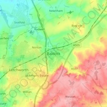
Name: Baldock topographic map, elevation, terrain.

Location: Baldock, North Hertfordshire, Hertfordshire, England, SG7 6AS, United Kingdom (51.94900 -0.22821 52.02900 -0.14821)

Average elevation: 295 ft

Minimum elevation: 125 ft

Maximum elevation: 499 ft

Other topographic maps

Click on a map to view its topography, its elevation and its terrain.

Gear up for your next adventure:

🪶LED Camping Lantern - Bright lantern for camp lighting
🪓Survival Multi‑Tool - Versatile tool for camp and trail tasks
🛰️Handheld GPS Units - Professional satellite navigators for precise backcountry mapping
🪵Folding Camp Saw - Compact saw for wood and campsite work
🚑Emergency Bivvies - Heat-reflective sleeping bags for survival situations

As an Amazon Associate, this site earns from qualifying purchases at no extra cost to you.