
Make a donation
Gear up for your next adventure:
As an Amazon Associate, this site earns from qualifying purchases at no extra cost to you.
Icaria topographic map
Click on the map to display elevation.
Make a donation
Gear up for your next adventure:
As an Amazon Associate, this site earns from qualifying purchases at no extra cost to you.
Icaria
Ikaria is one of the middle islands of the northern Aegean, 255.303 square kilometres (98.573 sq mi) in area with 102 miles (164 kilometres) of coastline and a population of 8,312 inhabitants. The topography is a contrast between verdant slopes and barren steep rocks. The island is mountainous for the most part. It is traversed by the Aetheras range, whose highest summit is 1,037 metres (3,402 feet). Most of its villages are nestled in the plains near the coast, with some in the mountains.
Make a donation
Gear up for your next adventure:
As an Amazon Associate, this site earns from qualifying purchases at no extra cost to you.
About this map
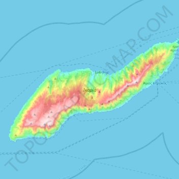
Name: Icaria topographic map, elevation, terrain.
Location: Icaria, Ikaria Regional Unit, Northern Aegean, Aegean, Greece (37.50869 25.97381 37.69119 26.36565)
Average elevation: 285 ft
Minimum elevation: 0 ft
Maximum elevation: 3,369 ft
Make a donation
Gear up for your next adventure:
As an Amazon Associate, this site earns from qualifying purchases at no extra cost to you.
Other topographic maps
Click on a map to view its topography, its elevation and its terrain.