
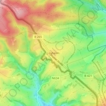
Losheim topographic map
Interactive map
Click on the map to display elevation.
About this map
Name: Losheim topographic map, elevation, terrain.
Average elevation: 1,909 ft
Minimum elevation: 1,654 ft
Maximum elevation: 2,211 ft
Other topographic maps
Click on a map to view its topography, its elevation and its terrain.
Schleiden
Allemagne > Rhénanie-du-Nord-Westphalie > Euskirchen
Schleiden, Euskirchen, Rhénanie-du-Nord-Westphalie, 53937, Allemagne
Average elevation: 1,480 ft
Hellenthal
Allemagne > Rhénanie-du-Nord-Westphalie > Euskirchen
Hellenthal, Euskirchen, Rhénanie-du-Nord-Westphalie, 53940, Allemagne
Average elevation: 1,860 ft
Blankenheim
Allemagne > Rhénanie-du-Nord-Westphalie > Euskirchen
Blankenheim, Euskirchen, Rhénanie-du-Nord-Westphalie, 53945, Allemagne
Average elevation: 1,647 ft