
Mirobod Tumani topographic map
Interactive map
Click on the map to display elevation.
About this map
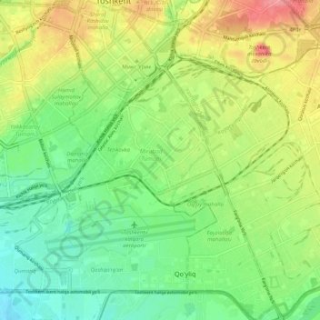
Name: Mirobod Tumani topographic map, elevation, terrain.
Location: Mirobod Tumani, Taschkent, 100000, Usbekistan (41.23753 69.26144 41.31238 69.32915)
Average elevation: 1,440 ft
Minimum elevation: 1,335 ft
Maximum elevation: 1,591 ft
Other topographic maps
Click on a map to view its topography, its elevation and its terrain.
Chilonzor Tumani
Chilonzor Tumani, Taschkent, 100000, Usbekistan
Average elevation: 1,391 ft
Taschkent
Taschkent, Yakkasaroy Tumani, Taschkent, 100128, Usbekistan
Average elevation: 1,467 ft
Yangi hayot Tumani
Yangi hayot Tumani, Taschkent, 100000, Usbekistan
Average elevation: 1,296 ft
Шайхантахурский район
Шайхантахурский район, Taschkent, 100000, Usbekistan
Average elevation: 2,218 ft
Mirzo Ulug‘bek Tumani
Mirzo Ulug‘bek Tumani, Taschkent, 100000, Usbekistan
Average elevation: 2,572 ft