
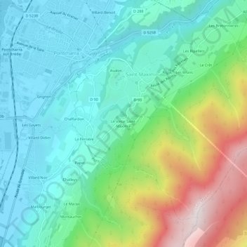
Le Vieux Saint-Maximin topographic map
Interactive map
Click on the map to display elevation.
About this map
Name: Le Vieux Saint-Maximin topographic map, elevation, terrain.
Average elevation: 1,677 ft
Minimum elevation: 807 ft
Maximum elevation: 3,944 ft
Other topographic maps
Click on a map to view its topography, its elevation and its terrain.
L'Échinal
France > Auvergne-Rhône-Alpes > Isère > Saint-Maximin > Le Vieux Saint-Maximin
L'Échinal, Le Vieux Saint-Maximin, Saint-Maximin, Grenoble, Isère, Auvergne-Rhône-Alpes, France métropolitaine, 38530, France
Average elevation: 1,549 ft
Les Ripellets
France > Auvergne-Rhône-Alpes > Isère > Saint-Maximin
Les Ripellets, Saint-Maximin, Grenoble, Isère, Auvergne-Rhône-Alpes, France métropolitaine, 38530, France
Average elevation: 1,736 ft
La Combe
France > Auvergne-Rhône-Alpes > Isère > Saint-Maximin
La Combe, Saint-Maximin, Grenoble, Isère, Auvergne-Rhône-Alpes, France métropolitaine, 38530, France
Average elevation: 1,434 ft