
Imlili topographic map
Interactive map
Click on the map to display elevation.
About this map
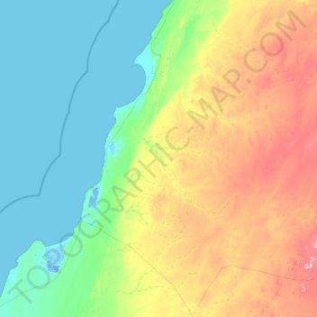
Name: Imlili topographic map, elevation, terrain.
Average elevation: 325 ft
Minimum elevation: -39 ft
Maximum elevation: 1,289 ft
Other topographic maps
Click on a map to view its topography, its elevation and its terrain.
La dune blanche
Maroc > cercle de El Argoub > El Argoub
La dune blanche, RN1, 阿尔古卜, El Argoub, caïdat de El Argoub, cercle de El Argoub, Dakhla-Oued Ed-Dahab, Maroc
Average elevation: 3 ft