
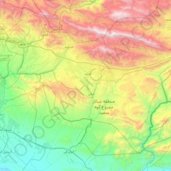
Central District (Damavand County) topographic map
Interactive map
Click on the map to display elevation.
About this map
Name: Central District (Damavand County) topographic map, elevation, terrain.
Average elevation: 6,401 ft
Minimum elevation: 2,881 ft
Maximum elevation: 13,255 ft
Other topographic maps
Click on a map to view its topography, its elevation and its terrain.
Rudehen
Rudehen, Rudehen District, Damavand County, Tehran Province, 39731-88981, Iran
Average elevation: 5,896 ft
Abali
Abali, Rudehen District, Damavand County, Iran
Average elevation: 7,589 ft
Rudafshan
Iran > Damavand County > دهستان ابرشیوه > Rudafshan
Rudafshan, دهستان ابرشیوه, Central District (Damavand County), Damavand County, Tehran Province, Iran
Average elevation: 6,818 ft
Abali
Iran > Damavand County > دهستان آبعلی > Abali
Abali, دهستان آبعلی, بخش رودهن, Damavand County, Tehran Province, Iran
Average elevation: 7,687 ft