Geolocate

Portillo topographic map

Click on the map to display elevation.

About this map

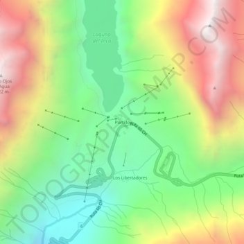
Name: Portillo topographic map, elevation, terrain.

Location: Portillo, Los Andes, Provincia de Los Andes, Valparaiso Region, Chile (-32.85642 -70.14908 -32.81642 -70.10908)

Average elevation: 10,486 ft

Minimum elevation: 8,025 ft

Maximum elevation: 13,891 ft

Other topographic maps

Click on a map to view its topography, its elevation and its terrain.

Gear up for your next adventure:

👓Polarized Sunglasses - Outdoor sunglasses for glare reduction
🔥Plasma Lighters - Windproof lighters that work in any weather condition
📡Handheld GPS Device - Reliable handheld GPS for outdoor navigation
🧤Tactile Hiking Gloves - Keep hands warm while operating GPS and smartphone screens
📶Satellite Messenger - Communication device off‑grid

As an Amazon Associate, this site earns from qualifying purchases at no extra cost to you.