
Make a donation
Gear up for your next adventure:
As an Amazon Associate, this site earns from qualifying purchases at no extra cost to you.
Belver topographic map
Click on the map to display elevation.
Make a donation
Gear up for your next adventure:
As an Amazon Associate, this site earns from qualifying purchases at no extra cost to you.
Belver
The parish is situated in river valley, 500 metres (1,600 ft) from the right margin of the Tagus River, along the confluence of the Ribeira de Belver. Its highest elevation is occupied by the 150 metres (490 ft) hilltop surmounted by the Castle of Belver, while the urban area is 125 metres (410 ft) above sea level. Surrounding these hilltops are several olive orchards.
Make a donation
Gear up for your next adventure:
As an Amazon Associate, this site earns from qualifying purchases at no extra cost to you.
About this map
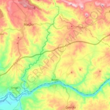
Name: Belver topographic map, elevation, terrain.
Location: Belver, Gavião, Portalegre, Portugal (39.47740 -8.00523 39.56509 -7.85110)
Average elevation: 686 ft
Minimum elevation: 85 ft
Maximum elevation: 1,342 ft
Make a donation
Gear up for your next adventure:
As an Amazon Associate, this site earns from qualifying purchases at no extra cost to you.