Make a donation
Gear up for your next adventure:
As an Amazon Associate, this site earns from qualifying purchases at no extra cost to you.
Passos topographic map
Click on the map to display elevation.
Make a donation
Gear up for your next adventure:
As an Amazon Associate, this site earns from qualifying purchases at no extra cost to you.
Passos
The city center of Passos is located at an elevation of 830 meters in a fertile region between the state boundary of São Paulo and the great reservoir of Furnas. Neighboring municipalities are: Delfinópolis (N), São João Batista do Glória and São José da Barra (E), Alpinópolis (SE), Jacuí (S), Fortaleza de Minas (SW), and Itaú de Minas and Cássia (W).
Make a donation
Gear up for your next adventure:
As an Amazon Associate, this site earns from qualifying purchases at no extra cost to you.
About this map
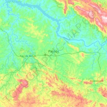
Name: Passos topographic map, elevation, terrain.
Average elevation: 2,769 ft
Minimum elevation: 2,162 ft
Maximum elevation: 4,711 ft
Make a donation
Gear up for your next adventure:
As an Amazon Associate, this site earns from qualifying purchases at no extra cost to you.
Other topographic maps
Click on a map to view its topography, its elevation and its terrain.
Make a donation
Gear up for your next adventure:
As an Amazon Associate, this site earns from qualifying purchases at no extra cost to you.
Make a donation
Gear up for your next adventure:
As an Amazon Associate, this site earns from qualifying purchases at no extra cost to you.
Unaí
Brazil > Minas Gerais > Região Integrada de Desenvolvimento do Distrito Federal e Entorno > Unaí > Unaí
Average elevation: 1,939 ft
Belo Horizonte
Brazil > Minas Gerais > Região Metropolitana de Belo Horizonte > Belo Horizonte
In 1893, due to the climatic and topographic conditions, Curral Del Rey was selected by Minas Gerais governor Afonso Pena among other cities as the location for the new economic and cultural center of the state, under the new name of Cidade de Minas, or City of Minas.
Average elevation: 2,966 ft
Make a donation
Gear up for your next adventure:
As an Amazon Associate, this site earns from qualifying purchases at no extra cost to you.
São Vicente
Brazil > Minas Gerais > Região Integrada de Desenvolvimento do Distrito Federal e Entorno > Buritis > São Vicente
Average elevation: 2,116 ft
