Geolocate

Pinehurst topographic map

Click on the map to display elevation.

About this map
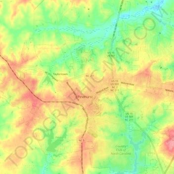
Name: Pinehurst topographic map, elevation, terrain.

Location: Pinehurst, Moore County, North Carolina, 28374, United States (35.15303 -79.52931 35.24771 -79.42244)

Average elevation: 453 ft

Minimum elevation: 308 ft

Maximum elevation: 600 ft

Moore County trails, hiking, mountain biking, running and outdoor activities

Other topographic maps

Click on a map to view its topography, its elevation and its terrain.
Westmoore

United States > North Carolina > Moore County

Average elevation: 535 ft

Lakeview

United States > North Carolina > Moore County

Average elevation: 292 ft

Sandhill

United States > North Carolina > Moore County > Foxfire

Average elevation: 456 ft

Gear up for your next adventure:

🚁Photography Drones - Capture stunning aerial views of landforms and topography
📷Action Cameras - Rugged cameras to document your journeys across rugged terrain
📖Nature Tracking Books - Learn to track wildlife and terrain
🗺️Topographic Maps - Detailed topo maps for hiking, exploring and outdoor navigation
❄️Traction Cleats - Prevent slips on icy trails during winter hikes

As an Amazon Associate, this site earns from qualifying purchases at no extra cost to you.