
Portage topographic map
Click on the map to display elevation.
About this map
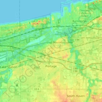
Name: Portage topographic map, elevation, terrain.
Location: Portage, Porter County, Indiana, United States (41.53604 -87.22257 41.64899 -87.12452)
Average elevation: 623 ft
Minimum elevation: 574 ft
Maximum elevation: 696 ft
Porter County trails, hiking, mountain biking, running and outdoor activities
Other topographic maps
Click on a map to view its topography, its elevation and its terrain.
Indiana Dunes State Park
United States > Indiana > Porter County > Chesterton
Average elevation: 610 ft
Beverly Shores
United States > Indiana > Porter County > Beverly Shores > Beverly Shores
Average elevation: 597 ft