Geolocate
👉 Easily get elevation data in JSON, GeoTIFF and KML formats using Elevation API
Thank you for supporting this site ❤️
Make a donation

Tongeren topographic map

Click on the map to display elevation.

About this map

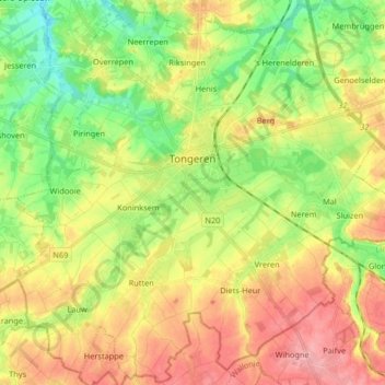
Name: Tongeren topographic map, elevation, terrain.

Location: Tongeren, Limburg, Flanders, 3700, Belgium (50.72015 5.38897 50.82236 5.55295)

Average elevation: 331 ft

Minimum elevation: 177 ft

Maximum elevation: 505 ft

Gear up for your next adventure:

🚑Emergency Bivvies - Heat-reflective sleeping bags for survival situations
🧭Hiking Compass - Precision compass for reliable navigation in the wilderness
🎒Hydration Pack - Hands‑free water reservoir for long hikes
📚USA Hiking Guide Books - Top trail guides and map books
👓Polarized Sunglasses - Outdoor sunglasses for glare reduction

As an Amazon Associate, this site earns from qualifying purchases at no extra cost to you.