
Rionegro topographic map
Click on the map to display elevation.
Rionegro
The city of Rionegro is located at 6°9′18″N 75°22′48″W / 6.15500°N 75.38000°W / 6.15500; -75.38000, at an average elevation of 2,125 metres (6,972 ft) above sea level. The average annual precipitation varies between 1,800 and 2,500 millimetres (71 and 98 in) with an average temperature of 17 °C or 62.6 °F. Much of the land consists of volcanic ashes and soils with a high resistance to erosion.
About this map
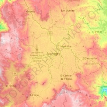
Name: Rionegro topographic map, elevation, terrain.
Average elevation: 7,323 ft
Minimum elevation: 4,731 ft
Maximum elevation: 9,193 ft