
Puerto Cabello topographic map
Interactive map
Click on the map to display elevation.
About this map
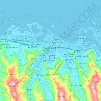
Name: Puerto Cabello topographic map, elevation, terrain.
Average elevation: 348 ft
Minimum elevation: -3 ft
Maximum elevation: 2,165 ft
Other topographic maps
Click on a map to view its topography, its elevation and its terrain.
La Pastora
Venezuela > Estado Carabobo > Municipio Puerto Cabello
La Pastora, Parroquia Democracia, Municipio Puerto Cabello, Estado Carabobo, Venezuela
Average elevation: 794 ft
Puerto Cabello
Venezuela > Estado Carabobo > Municipio Puerto Cabello
Puerto Cabello, Parroquia Juan José Flores, Municipio Puerto Cabello, Estado Carabobo, 2050, Venezuela
Average elevation: 961 ft