
Byars topographic map
Interactive map
Click on the map to display elevation.
About this map
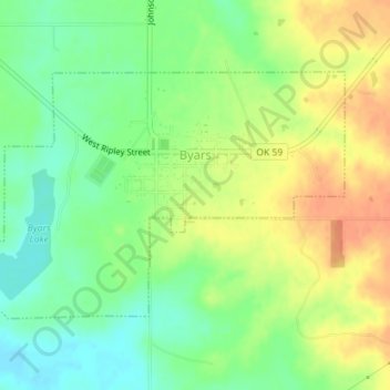
Name: Byars topographic map, elevation, terrain.
Location: Byars, McClain County, Oklahoma, United States (34.86197 -97.07187 34.88044 -97.03639)
Average elevation: 1,033 ft
Minimum elevation: 961 ft
Maximum elevation: 1,109 ft
Other topographic maps
Click on a map to view its topography, its elevation and its terrain.
Rosedale
United States > Oklahoma > McClain County
Rosedale, McClain County, Oklahoma, United States
Average elevation: 1,037 ft
Goldsby
United States > Oklahoma > McClain County
Goldsby, McClain County, Oklahoma, United States
Average elevation: 1,148 ft
Wayne
United States > Oklahoma > McClain County
Wayne, McClain County, Oklahoma, United States
Average elevation: 1,093 ft
Purcell
United States > Oklahoma > McClain County
Purcell, McClain County, Oklahoma, United States
Average elevation: 1,093 ft
Blanchard
United States > Oklahoma > McClain County
Blanchard, McClain County, Oklahoma, 73010, United States
Average elevation: 1,260 ft
Newcastle
United States > Oklahoma > McClain County
Newcastle, McClain County, Oklahoma, 73065, United States
Average elevation: 1,224 ft