
Rome topographic map
Interactive map
Click on the map to display elevation.
About this map
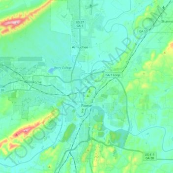
Name: Rome topographic map, elevation, terrain.
Location: Rome, Floyd County, Georgia, United States (34.19316 -85.27894 34.35650 -85.11225)
Average elevation: 692 ft
Minimum elevation: 528 ft
Maximum elevation: 1,499 ft
Other topographic maps
Click on a map to view its topography, its elevation and its terrain.
Radio Springs
United States > Georgia > Floyd County
Radio Springs, Floyd County, Georgia, United States
Average elevation: 797 ft
Lindale
United States > Georgia > Floyd County
Lindale, Floyd County, Georgia, 30147, United States
Average elevation: 751 ft
Shannon
United States > Georgia > Floyd County
Shannon, Floyd County, Georgia, 30172, United States
Average elevation: 692 ft
Garden Lakes, City of Rome
United States > Georgia > Floyd County
Garden Lakes, City of Rome, Floyd County, Georgia, United States
Average elevation: 646 ft
Cave Spring
United States > Georgia > Floyd County
Cave Spring, Floyd County, Georgia, United States
Average elevation: 778 ft
Berryhill
United States > Georgia > Floyd County > Rome
Berryhill, Rome, Floyd County, Georgia, 30165, United States
Average elevation: 679 ft
Cave Spring
United States > Georgia > Floyd County > Cave Spring
Cave Spring, Floyd County, Georgia, 30124, United States
Average elevation: 771 ft