
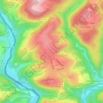
Preischeid topographic map
Interactive map
Click on the map to display elevation.
About this map
Name: Preischeid topographic map, elevation, terrain.
Average elevation: 1,230 ft
Minimum elevation: 833 ft
Maximum elevation: 1,631 ft
Other topographic maps
Click on a map to view its topography, its elevation and its terrain.
Bollendorf
Germany > Rhineland-Palatinate > Eifelkreis Bitburg-Prüm > Bollendorf
Bollendorf, Südeifel, Eifelkreis Bitburg-Prüm, Rhineland-Palatinate, 54669, Germany
Average elevation: 1,020 ft
Spangdahlem
Germany > Rhineland-Palatinate > Eifelkreis Bitburg-Prüm
Spangdahlem, Speicher, Eifelkreis Bitburg-Prüm, Rhineland-Palatinate, 54529, Germany
Average elevation: 1,093 ft
Herforst
Germany > Rhineland-Palatinate > Eifelkreis Bitburg-Prüm > Herforst
Herforst, Speicher, Eifelkreis Bitburg-Prüm, Rhineland-Palatinate, Germany
Average elevation: 1,115 ft
Alsdorf
Germany > Rhineland-Palatinate > Eifelkreis Bitburg-Prüm > Alsdorf
Alsdorf, Südeifel, Eifelkreis Bitburg-Prüm, Rhineland-Palatinate, Germany
Average elevation: 932 ft
Auw bei Prüm
Germany > Rhineland-Palatinate > Eifelkreis Bitburg-Prüm > Auw bei Prüm
Auw bei Prüm, Prüm, Eifelkreis Bitburg-Prüm, Rhineland-Palatinate, Germany
Average elevation: 1,811 ft