
Denkanikottai topographic map
Interactive map
Click on the map to display elevation.
About this map
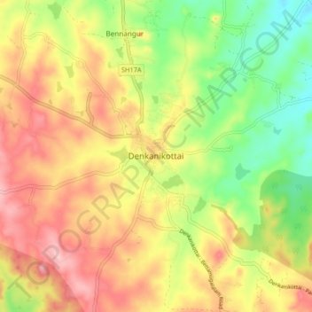
Name: Denkanikottai topographic map, elevation, terrain.
Location: Denkanikottai, Krishnagiri District, Tamil Nadu, 635107, India (12.48709 77.75262 12.56709 77.83262)
Average elevation: 2,861 ft
Minimum elevation: 2,585 ft
Maximum elevation: 3,127 ft
Denkanikottai also known as Thenkanikottai is a semi-urban Panchayat Town in Krishnagiri district in the state of Tamil Nadu, India. It is the headquarters of Denkanikottai Taluk. Its altitude 879 m (2,884 ft) elevation above the sea level. It is a multicultural town with a mix of linguistic groups. Tamil is the official and spoken language. There are a significant number of Kannada, Urdu and Telugu and speakers in the town as it is very near to Karnataka State bordering it. The place is named after the legend of Betrayaswamy Temple located in the centre of the town.
Other topographic maps
Click on a map to view its topography, its elevation and its terrain.
Bettamugilalam
India > Tamil Nadu > Denkanikottai
Bettamugilalam, Denkanikottai, Krishnagiri District, Tamil Nadu, India
Average elevation: 3,474 ft
Rayakottai
India > Tamil Nadu > Denkanikottai
Rayakottai, Denkanikottai, Krishnagiri District, Tamil Nadu, India
Average elevation: 2,316 ft
Kelamangalam
India > Tamil Nadu > Denkanikottai
Kelamangalam, Denkanikottai, Krishnagiri District, Tamil Nadu, 635113, India
Average elevation: 2,648 ft
Gumalapura
India > Tamil Nadu > Denkanikottai
Gumalapura, Denkanikottai, Krishnagiri District, Tamil Nadu, 635118, India
Average elevation: 3,077 ft
Thalli
India > Tamil Nadu > Denkanikottai
Thalli, Denkanikottai, Krishnagiri District, Tamil Nadu, 635118, India
Average elevation: 3,005 ft
Chinnapariddiplaiyam
India > Tamil Nadu > Denkanikottai > Chinnapariddiplaiyam
Chinnapariddiplaiyam, Denkanikottai, Krishnagiri District, Tamil Nadu, India
Average elevation: 2,904 ft