
Tegerfelden topographic map
Interactive map
Click on the map to display elevation.
About this map
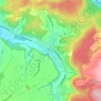
Name: Tegerfelden topographic map, elevation, terrain.
Location: Tegerfelden, Bezirk Zurzach, Aargau, 5306, Schweiz (47.54487 8.26267 47.57651 8.30947)
Average elevation: 1,430 ft
Minimum elevation: 1,079 ft
Maximum elevation: 1,880 ft
Other topographic maps
Click on a map to view its topography, its elevation and its terrain.
Hörndli
Schweiz > Aargau > Bezirk Zurzach > Zurzach
Hörndli, Zurzach, Bezirk Zurzach, Aargau, 5330, Schweiz
Average elevation: 1,319 ft
Bad Zurzach
Schweiz > Aargau > Bezirk Zurzach > Zurzach
Bad Zurzach, Zurzach, Bezirk Zurzach, Aargau, 5330, Schweiz
Average elevation: 1,293 ft
Siglistorf
Schweiz > Aargau > Bezirk Zurzach
Siglistorf, Bezirk Zurzach, Aargau, 5462, Schweiz
Average elevation: 1,752 ft
Lengnau
Schweiz > Aargau > Bezirk Zurzach
Lengnau, Bezirk Zurzach, Aargau, 5426, Schweiz
Average elevation: 1,680 ft