Geolocate

Banquerohan topographic map

Click on the map to display elevation.

About this map

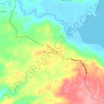
Name: Banquerohan topographic map, elevation, terrain.

Location: Banquerohan, Legazpi, Albay, Bicol Region, 4714, Philippines (13.03528 123.72658 13.07528 123.76658)

Average elevation: 164 ft

Minimum elevation: -10 ft

Maximum elevation: 407 ft

Other topographic maps

Click on a map to view its topography, its elevation and its terrain.

Peñaranda Park

Philippines > Albay > Legazpi > Baño

Average elevation: 121 ft

Gear up for your next adventure:

🦶Hiking Gaiters - Keep debris and water out of your boots
🔦Powerful Headlamps - Ultra-bright hands-free lighting for night navigation
🧥Waterproof Jacket for Hiking - Breathable and rugged rain jacket for outdoor excursions
🪶Multi‑Purpose Knife - Useful blade for camp and trail
🧭Outdoor Navigation Book - Learn advanced navigation skills

As an Amazon Associate, this site earns from qualifying purchases at no extra cost to you.