
Grafton topographic map
Interactive map
Click on the map to display elevation.
About this map
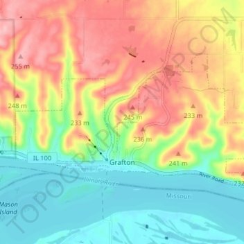
Name: Grafton topographic map, elevation, terrain.
Location: Grafton, Jersey County, Illinois, 62307, United States (38.96384 -90.45988 38.99228 -90.39490)
Average elevation: 610 ft
Minimum elevation: 413 ft
Maximum elevation: 853 ft
Other topographic maps
Click on a map to view its topography, its elevation and its terrain.
Jerseyville
United States > Illinois > Jersey County
Jerseyville, Jersey County, Illinois, 62052, United States
Average elevation: 617 ft
Chautauqua
United States > Illinois > Jersey County > Chautauqua
Chautauqua, Jersey County, Illinois, 52028, United States
Average elevation: 548 ft