Geolocate

Brookfield topographic map

Click on the map to display elevation.

About this map

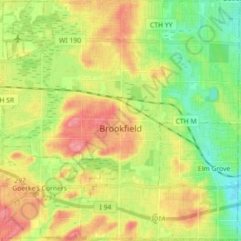
Name: Brookfield topographic map, elevation, terrain.

Location: Brookfield, Waukesha County, Wisconsin, United States (43.01640 -88.18589 43.10626 -88.06613)

Average elevation: 840 ft

Minimum elevation: 722 ft

Maximum elevation: 978 ft

Waukesha County trails, hiking, mountain biking, running and outdoor activities

Other topographic maps

Click on a map to view its topography, its elevation and its terrain.

Lapham Hill

United States > Wisconsin > Waukesha County

Average elevation: 1,030 ft

Eagleville

United States > Wisconsin > Waukesha County

Average elevation: 860 ft

Mukwonago Park

United States > Wisconsin > Waukesha County

Average elevation: 876 ft

Gear up for your next adventure:

🏕️Family Camping Gear - Essentials for group camping trips
❄️Traction Cleats - Prevent slips on icy trails during winter hikes
🔭Telescopic Hiking Pole - Adjustable pole for hiking stability
🦺Reflective Outdoor Gear - Safety gear for low‑light conditions
🏕️Tent Footprint - Protect your tent base from wear

As an Amazon Associate, this site earns from qualifying purchases at no extra cost to you.