Geolocate

Orcines topographic map

Click on the map to display elevation.

About this map

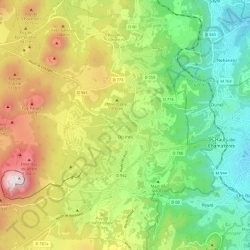
Name: Orcines topographic map, elevation, terrain.

Location: Orcines, Clermont-Ferrand, Puy-de-Dôme, Auvergne-Rhône-Alpes, Metropolitan France, 63870, France (45.75049 2.94390 45.82748 3.05331)

Average elevation: 2,644 ft

Minimum elevation: 1,283 ft

Maximum elevation: 4,770 ft

Other topographic maps

Click on a map to view its topography, its elevation and its terrain.

Les Chaux

France > Auvergne-Rhône-Alpes > Puy-de-Dôme > Olliergues

Average elevation: 1,693 ft

Gear up for your next adventure:

🎒Waterproof Dry Bags - Keep your electronics and maps dry inside your pack
👟Men's Trail Runners - Lightweight footwear for fast-paced exploration and light hiking
🧭Outdoor Navigation Book - Learn advanced navigation skills
🌧️Backpack Rain Cover - Keep gear dry in wet weather
🕶️GPS Smartphone Mount - Secure mount for phone navigation

As an Amazon Associate, this site earns from qualifying purchases at no extra cost to you.