
Sion topographic map
Interactive map
Click on the map to display elevation.
About this map
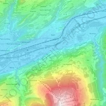
Name: Sion topographic map, elevation, terrain.
Location: Sion, Wallis, 1950, Switzerland (46.17805 7.30536 46.25585 7.42527)
Average elevation: 2,910 ft
Minimum elevation: 1,562 ft
Maximum elevation: 7,290 ft
Other topographic maps
Click on a map to view its topography, its elevation and its terrain.
Sex Noir
Switzerland > Wallis > Sion > Arbaz
Sex Noir, Arbaz, Sion, Wallis, 1974, Switzerland
Average elevation: 7,513 ft
Veysonnaz
Switzerland > Wallis > Sion
Veysonnaz, Sion, Wallis, 1993, Switzerland
Average elevation: 3,346 ft
Les Mountons
Switzerland > Wallis > Sion > Savièse
Les Mountons, Savièse, Sion, Wallis, 1965, Switzerland
Average elevation: 7,310 ft