
Maluti-a-Phofung Ward 6 topographic map
Interactive map
Click on the map to display elevation.
About this map
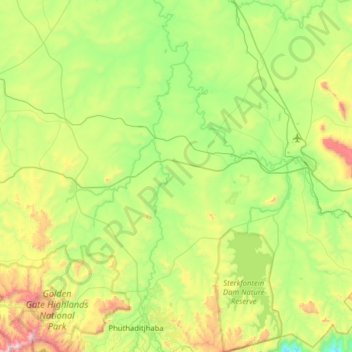
Name: Maluti-a-Phofung Ward 6 topographic map, elevation, terrain.
Average elevation: 5,673 ft
Minimum elevation: 4,275 ft
Maximum elevation: 9,170 ft
Other topographic maps
Click on a map to view its topography, its elevation and its terrain.
Phuthaditjhaba
South Africa > Free State > Thabo Mofutsanyana District Municipality > Maluti-a-Phofung Local Municipality
Phuthaditjhaba, Maluti-a-Phofung Local Municipality, Thabo Mofutsanyana District Municipality, Free State, 9866, South Africa
Average elevation: 5,696 ft
Rainfall Dam
South Africa > Free State > Thabo Mofutsanyana District Municipality > Maluti-a-Phofung Local Municipality
Rainfall Dam, Maluti-a-Phofung Ward 22, Maluti-a-Phofung Local Municipality, Thabo Mofutsanyana District Municipality, Free State, South Africa
Average elevation: 5,600 ft
iNtabazwe (Harrismith)
South Africa > Free State > Thabo Mofutsanyana District Municipality > Maluti-a-Phofung Local Municipality
iNtabazwe (Harrismith), Maluti-a-Phofung Local Municipality, Thabo Mofutsanyana District Municipality, Free State, 9880, South Africa
Average elevation: 5,630 ft
Sterkfontein Dam
South Africa > Free State > Thabo Mofutsanyana District Municipality > Maluti-a-Phofung Local Municipality
Sterkfontein Dam, Maluti-a-Phofung Ward 6, Maluti-a-Phofung Local Municipality, Thabo Mofutsanyana District Municipality, Free State, South Africa
Average elevation: 5,502 ft
Maluti-a-Phofung Ward 11
South Africa > Free State > Thabo Mofutsanyana District Municipality > Maluti-a-Phofung Local Municipality
Maluti-a-Phofung Ward 11, Maluti-a-Phofung Local Municipality, Thabo Mofutsanyana District Municipality, Free State, South Africa
Average elevation: 6,726 ft