Geolocate

Richat Structure topographic map

Click on the map to display elevation.

About this map
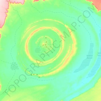
Name: Richat Structure topographic map, elevation, terrain.

Location: Richat Structure, Adrar, Mauritania (20.95626 -11.56260 21.25345 -11.20524)

Average elevation: 1,319 ft

Minimum elevation: 1,145 ft

Maximum elevation: 1,985 ft

Other topographic maps

Click on a map to view its topography, its elevation and its terrain.

Ouadane

Mauritania > Adrar

Average elevation: 1,526 ft

Hofer Tijanna

Mauritania > Adrar

Average elevation: 348 ft

Ouadane

Mauritania > Adrar

Average elevation: 1,526 ft

Ksar el Khâli

Mauritania > Adrar > Ouadane

Average elevation: 1,440 ft

Grâret en Nemra

Mauritania > Adrar

Average elevation: 338 ft

Gear up for your next adventure:

🥾Women's Hiking Boots - Top-rated trail boots with ankle support and superior grip
🧤Hiking Gloves - Protective gloves for rugged trails
🛶Inflatable Kayak - Portable kayak for rivers, lakes, and expeditions
📚USA Hiking Guide Books - Top trail guides and map books
🏫Relief Map Kits - Hands-on tools for teaching landforms and elevation

As an Amazon Associate, this site earns from qualifying purchases at no extra cost to you.