
Make a donation
Gear up for your next adventure:
As an Amazon Associate, this site earns from qualifying purchases at no extra cost to you.
Wytheville topographic map
Click on the map to display elevation.
Make a donation
Gear up for your next adventure:
As an Amazon Associate, this site earns from qualifying purchases at no extra cost to you.
Wytheville
Wytheville is nestled within the scenic Appalachian Mountains, characterized by a varied topography that features rolling hills, gentle valleys, and steep ridges. The town sits at an elevation of approximately 2,300 feet, which contributes to its cooler climate and offers picturesque views of the surrounding landscape. The region is interspersed with streams and rivers that carve through the terrain, creating a mix of lush greenery and rocky outcrops. Dense forests, primarily composed of hardwoods, blanket the hillsides, while the occasional open pasture enhances the area's agricultural charm. This diverse topography not only provides a stunning backdrop but also supports a range of outdoor recreational activities, making Wytheville a gateway to exploring the natural beauty of Southwest Virginia.
Make a donation
Gear up for your next adventure:
As an Amazon Associate, this site earns from qualifying purchases at no extra cost to you.
About this map
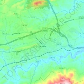
Name: Wytheville topographic map, elevation, terrain.
Location: Wytheville, Wythe County, Virginia, 24382, United States (36.92258 -81.13589 36.98165 -81.03117)
Average elevation: 2,362 ft
Minimum elevation: 2,037 ft
Maximum elevation: 3,474 ft
Wythe County trails, hiking, mountain biking, running and outdoor activities
Make a donation
Gear up for your next adventure:
As an Amazon Associate, this site earns from qualifying purchases at no extra cost to you.
Other topographic maps
Click on a map to view its topography, its elevation and its terrain.
Make a donation
Gear up for your next adventure:
As an Amazon Associate, this site earns from qualifying purchases at no extra cost to you.
Stones Mill
United States > Virginia > Wythe County > Wytheville > Stones Mill
Average elevation: 2,329 ft
Make a donation
Gear up for your next adventure:
As an Amazon Associate, this site earns from qualifying purchases at no extra cost to you.