Geolocate

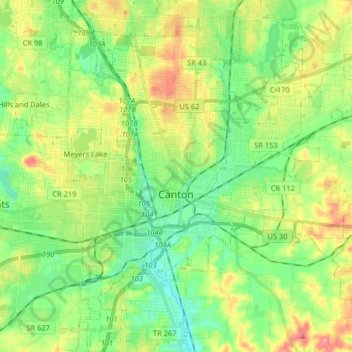
Canton topographic map

Click on the map to display elevation.

Canton

Canton is located at an elevation of 1,060 feet (323 m). Nimishillen Creek and its East, Middle and West Branches flow through the city.

Wikipedia (CC-BY-SA 3.0)

About this map

Name: Canton topographic map, elevation, terrain.

Location: Canton, Stark County, Ohio, United States (40.74364 -81.42934 40.90667 -81.28472)

Average elevation: 1,115 ft

Minimum elevation: 991 ft

Maximum elevation: 1,286 ft

Stark County trails, hiking, mountain biking, running and outdoor activities

Other topographic maps

Click on a map to view its topography, its elevation and its terrain.
Mount Pleasant

United States > Ohio > Stark County

Average elevation: 1,155 ft

Cairo

United States > Ohio > Stark County

Average elevation: 1,145 ft

Deer Creek

United States > Ohio > Stark County > Lexington

Average elevation: 1,047 ft

Sippo Heights

United States > Ohio > Stark County > Massillon

Average elevation: 1,043 ft

Crystal Springs

United States > Ohio > Stark County

Average elevation: 1,020 ft

Lake Cable

United States > Ohio > Stark County

Average elevation: 1,115 ft

North Industry

United States > Ohio > Stark County

Average elevation: 1,093 ft

Gear up for your next adventure:

🪶Survival Guide Book - Expert advice for emergency preparedness
⛺Backpacking Tents - Weight-optimized shelters for multi-day topographic surveys
⌚Solar GPS Watches - Advanced multisport watches with built-in topographic maps
🚗GPS Dash Cams - Record your scenic drives through mountain passes and canyons
🪶LED Camping Lantern - Bright lantern for camp lighting

As an Amazon Associate, this site earns from qualifying purchases at no extra cost to you.