
Remchi topographic map
Interactive map
Click on the map to display elevation.
About this map
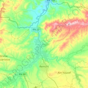
Name: Remchi topographic map, elevation, terrain.
Location: Remchi, Daïra Remchi, Tlemcen, Algérie (35.01102 -1.51092 35.21703 -1.38430)
Average elevation: 715 ft
Minimum elevation: 52 ft
Maximum elevation: 2,156 ft
Other topographic maps
Click on a map to view its topography, its elevation and its terrain.
Beni Ouarsous
Algérie > Tlemcen > Daïra Remchi
Beni Ouarsous, Daïra Remchi, Tlemcen, Algérie
Average elevation: 988 ft
Sidi Bendhiaf
Algérie > Tlemcen > Daïra Remchi > Beni Ouarsous
Sidi Bendhiaf, Beni Ouarsous, Daïra Remchi, Tlemcen, Algérie
Average elevation: 902 ft
Dahmane
Algérie > Tlemcen > Daïra Remchi > Beni Ouarsous
Dahmane, Beni Ouarsous, Daïra Remchi, Tlemcen, Algérie
Average elevation: 600 ft