
双龙风景名胜区 topographic map
Interactive map
Click on the map to display elevation.
About this map
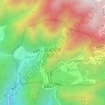
Name: 双龙风景名胜区 topographic map, elevation, terrain.
Location: 双龙风景名胜区, 新朝线, 婺城区, 金华市, 浙江省, 中国 (29.19820 119.61394 29.21539 119.64357)
Average elevation: 2,159 ft
Minimum elevation: 712 ft
Maximum elevation: 3,812 ft
Other topographic maps
Click on a map to view its topography, its elevation and its terrain.