
Rogers City topographic map
Interactive map
Click on the map to display elevation.
About this map
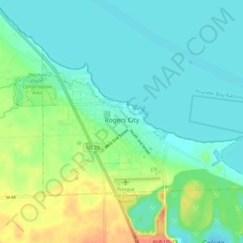
Name: Rogers City topographic map, elevation, terrain.
Average elevation: 617 ft
Minimum elevation: 564 ft
Maximum elevation: 761 ft
Other topographic maps
Click on a map to view its topography, its elevation and its terrain.
North Allis Township
United States > Michigan > Presque Isle County
North Allis Township, Presque Isle County, Michigan, United States
Average elevation: 735 ft
Sinkhole
United States > Michigan > Presque Isle County > Presque Isle Township
Sinkhole, Presque Isle Township, Presque Isle County, Michigan, United States
Average elevation: 630 ft
Ocqueoc
United States > Michigan > Presque Isle County
Ocqueoc, Ocqueoc Township, Presque Isle County, Michigan, United States
Average elevation: 741 ft
Case Township
United States > Michigan > Presque Isle County
Case Township, Presque Isle County, Michigan, United States
Average elevation: 830 ft
Hessler Lake
United States > Michigan > Presque Isle County
Hessler Lake, Case Township, Presque Isle County, Michigan, United States
Average elevation: 853 ft
Presque Isle Township
United States > Michigan > Presque Isle County
Presque Isle Township, Presque Isle County, Michigan, 49777, United States
Average elevation: 614 ft
Posen
United States > Michigan > Presque Isle County
Posen, Posen Township, Presque Isle County, Michigan, United States
Average elevation: 781 ft
Grand Island
United States > Michigan > Presque Isle County > Presque Isle Township
Grand Island, Presque Isle Township, Presque Isle County, Michigan, United States
Average elevation: 597 ft
Manitou Beach
United States > Michigan > Presque Isle County > Manitou Beach
Manitou Beach, Rogers Township, Presque Isle County, Michigan, United States
Average elevation: 604 ft