
Make a donation
Gear up for your next adventure:
As an Amazon Associate, this site earns from qualifying purchases at no extra cost to you.
Case Township topographic map
Click on the map to display elevation.
Make a donation
Gear up for your next adventure:
As an Amazon Associate, this site earns from qualifying purchases at no extra cost to you.
About this map
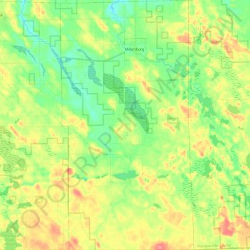
Name: Case Township topographic map, elevation, terrain.
Location: Case Township, Presque Isle County, Michigan, United States (45.19861 -84.13202 45.36744 -84.00390)
Average elevation: 830 ft
Minimum elevation: 738 ft
Maximum elevation: 961 ft
Presque Isle County trails, hiking, mountain biking, running and outdoor activities
Make a donation
Gear up for your next adventure:
As an Amazon Associate, this site earns from qualifying purchases at no extra cost to you.
Other topographic maps
Click on a map to view its topography, its elevation and its terrain.
Orchard Point
United States > Michigan > Presque Isle County > Presque Isle Township
Average elevation: 650 ft
Drum Lake
United States > Michigan > Presque Isle County > Bismarck Township
Average elevation: 833 ft
Make a donation
Gear up for your next adventure:
As an Amazon Associate, this site earns from qualifying purchases at no extra cost to you.