
Thompson's Lake State Park topographic map
Interactive map
Click on the map to display elevation.
About this map
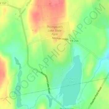
Name: Thompson's Lake State Park topographic map, elevation, terrain.
Average elevation: 1,345 ft
Minimum elevation: 1,243 ft
Maximum elevation: 1,476 ft
Other topographic maps
Click on a map to view its topography, its elevation and its terrain.
West Township
United States > New York > Albany County > Town of Knox
West Township, Town of Knox, Albany County, New York, 12107, United States
Average elevation: 1,273 ft
West Berne
United States > New York > Albany County > Town of Knox
West Berne, Town of Knox, Albany County, New York, 12023, United States
Average elevation: 1,056 ft
East Township
United States > New York > Albany County > Town of Knox
East Township, Town of Knox, Albany County, New York, 12107, United States
Average elevation: 1,089 ft