
Lakeport topographic map
Interactive map
Click on the map to display elevation.
About this map
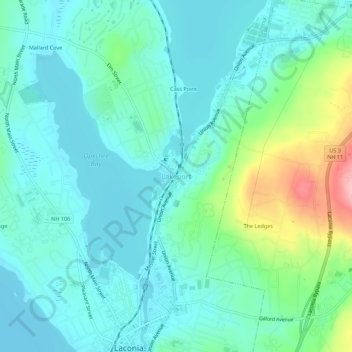
Name: Lakeport topographic map, elevation, terrain.
Average elevation: 591 ft
Minimum elevation: 479 ft
Maximum elevation: 994 ft
Other topographic maps
Click on a map to view its topography, its elevation and its terrain.
Weirs Beach
United States > New Hampshire > Belknap County > Laconia > Interlaken Park
Weirs Beach, Interlaken Park, Laconia, Belknap County, New Hampshire, 03247, United States
Average elevation: 587 ft
Laconia
United States > New Hampshire > Belknap County > Laconia
Laconia, Belknap County, New Hampshire, 03246, United States
Average elevation: 745 ft