
Mallanganee National Park topographic map
Interactive map
Click on the map to display elevation.
About this map
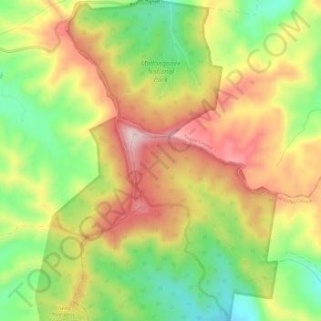
Name: Mallanganee National Park topographic map, elevation, terrain.
Average elevation: 938 ft
Minimum elevation: 404 ft
Maximum elevation: 1,483 ft
Other topographic maps
Click on a map to view its topography, its elevation and its terrain.
Mallanganee
Australia > New South Wales > Mallanganee
Mallanganee, Kyogle Council, New South Wales, 2469, Australia
Average elevation: 725 ft
Mallanganee
Australia > New South Wales > Mallanganee
Mallanganee, Kyogle Council, New South Wales, 2469, Australia
Average elevation: 771 ft