
Бия topographic map
Interactive map
Click on the map to display elevation.
About this map
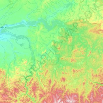
Name: Бия topographic map, elevation, terrain.
Average elevation: 1,594 ft
Minimum elevation: 538 ft
Maximum elevation: 6,654 ft
Other topographic maps
Click on a map to view its topography, its elevation and its terrain.
Biïsk
Russie > Kraï de l'Altaï > Biïsk
Biïsk, городской округ Бийск, Kraï de l'Altaï, District fédéral sibérien, 659300, Russie
Average elevation: 646 ft
Смоленский район
Смоленский район, Kraï de l'Altaï, District fédéral sibérien, Russie
Average elevation: 1,086 ft