
Laurium topographic map
Interactive map
Click on the map to display elevation.
About this map
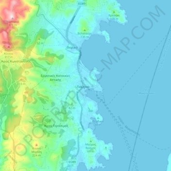
Name: Laurium topographic map, elevation, terrain.
Average elevation: 174 ft
Minimum elevation: -3 ft
Maximum elevation: 1,194 ft
Other topographic maps
Click on a map to view its topography, its elevation and its terrain.
Thorikos Ormos
Thorikos Ormos, Μπλέντα-Οξυγόνο, Lavrio Camp, Laurium, Municipality of Lavreotiki, Regional Unit of East Attica, Region of Attica, Attica, 19500, Greece
Average elevation: 23 ft