
Candal topographic map
Interactive map
Click on the map to display elevation.
About this map
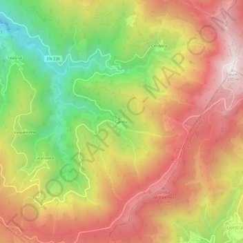
Name: Candal topographic map, elevation, terrain.
Location: Candal, Lousã e Vilarinho, Lousã, Coimbra, 3200-120, Portugal (40.06121 -8.22290 40.10121 -8.18290)
Average elevation: 2,549 ft
Minimum elevation: 899 ft
Maximum elevation: 3,944 ft
Other topographic maps
Click on a map to view its topography, its elevation and its terrain.
Quatro Águas
Portugal > Coimbra > Lousã > Serpins
Quatro Águas, Serpins, Lousã, Coimbra, 3200-358, Portugal
Average elevation: 843 ft
Catarredor
Catarredor, Lousã e Vilarinho, Lousã, Coimbra, 3200-120, Portugal
Average elevation: 2,444 ft